wiki.Ömans.se

Sockenkatalog för släktforskare

Användarverktyg

Webbverktyg


plats:us:saint-louis.mn.co

Saint Louis (MN) county

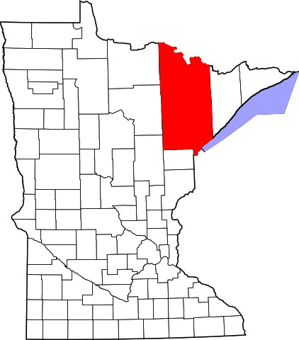
Saint Louis County är ett administrativt område i delstaten Minnesota i USA. År 2010 hade countyt 200 226 invånare. Den administrativa huvudorten (county seat) är Duluth. Countyt är det största i Minnesota, och även det största öster om Mississippifloden.

, , ,

Översikt

Historik

This area was long inhabited by Algonquian-speaking tribes: the Ojibwe (Chippewa), Ottawa and Potawatomi peoples were loosely affiliated in the Council of Three Fires. As American settlers entered the territory, the Native Americans were pushed to outer areas.

The Minnesota Legislature established St. Louis County on February 20, 1855, as Doty County, and changed its name to Newton County on March 3, 1855. It originally consisted of the area east and south of the St. Louis River, while the area east of the Vermilion River and north of the St. Louis River was part of Superior County. Superior County was renamed St. Louis County.

On March 1, 1856, that St. Louis County was renamed as Lake County. Newton County was renamed as St. Louis County and had that eastern area added to it; it was also expanded westward by incorporating parts of Itasca County, which then also included most of Carlton County. On May 23, 1857, St. Louis County took its current shape when Carlton County was formed from parts of St. Louis and Pine counties.

Övrigt

består av

Cities

  • Aurora
  • Babbitt
  • Biwabik
  • Brookston
  • Buhl
  • Chisholm
  • Cook
  • Duluth (MN) city (county seat)
  • Ely
  • Eveleth
  • Floodwood
  • Gilbert
  • Hermantown
  • Hibbing
  • Hoyt Lakes
  • Iron Junction
  • Kinney
  • Leonidas
  • McKinley
  • Meadowlands
  • Mountain Iron
  • Orr
  • Proctor
  • Rice Lake
  • Tower
  • Virginia
  • Winton

Townships

  • Alango Township
  • Alborn Township
  • Alden Township
  • Angora Township
  • Arrowhead Township
  • Ault Township
  • Balkan Township
  • Bassett Township
  • Beatty Township
  • Biwabik Township
  • Breitung Township
  • Brevator Township
  • Camp 5 Township
  • Canosia Township
  • Cedar Valley Township
  • Cherry Township
  • Clinton Township
  • Colvin Township
  • Cotton Township
  • Crane Lake Township
  • Culver Township
  • Duluth Township
  • Eagles Nest Township
  • Ellsburg Township
  • Elmer Township
  • Embarrass Township
  • Fairbanks Township
  • Fayal Township
  • Field Township
  • Fine Lakes Township
  • Floodwood Township
  • Fredenberg Township
  • French Township
  • Gnesen Township
  • Grand Lake Township
  • Great Scott Township
  • Greenwood Township
  • Halden Township
  • Industrial Township
  • Kabetogama Township
  • Kelsey Township
  • Kugler Township
  • Lakewood Township
  • Lavell Township
  • Leiding Township
  • Linden Grove Township
  • McDavitt Township
  • Meadowlands Township
  • Midway Township
  • Morcom Township
  • Morse Township
  • Ness Township
  • New Independence Township
  • Normanna Township
  • North Star Township
  • Northland Township
  • Owens Township
  • Pequaywan Township
  • Pike Township
  • Portage Township
  • Prairie Lake Township
  • Sandy Township
  • Solway Township
  • Stoney Brook Township
  • Sturgeon Township
  • Toivola Township
  • Van Buren Township
  • Vermilion Lake Township
  • Waasa Township
  • White Township
  • Willow Valley Township
  • Wuori Township

Unorganized territories

  • Angleworm Lake
  • Bear Head Lake
  • Birch Lake
  • Camp A Lake
  • Crab Lake
  • Dark River
  • Gheen
  • Hay Lake
  • Heikkala Lake
  • Hush Lake
  • Janette Lake
  • Leander Lake
  • Linwood Lake
  • Marion Lake
  • McCormack
  • Mud Hen Lake
  • Nett Lake
  • Northeast St. Louis
  • Northwest St. Louis
  • Pfeiffer Lake
  • Picket Lake
  • Potshot Lake
  • Sand Lake
  • Slim Lake
  • Sturgeon River
  • Sunday Lake
  • Tikander Lake
  • Whiteface Reservoir

Census-designated places

  • Mahnomen
  • Nett Lake
  • Soudan

Unincorporated communities

  • Alborn
  • Angora
  • Ash Lake
  • Bassett
  • Bear River
  • Bengal
  • Brimson
  • Britt
  • Burnett
  • Burntside
  • Buyck
  • Canyon
  • Celina
  • Central Lakes
  • Cherry
  • Clover Valley
  • Cotton
  • Crane Lake
  • Culver
  • Cusson
  • Eldes Corner
  • Elmer
  • Embarrass
  • Fairbanks
  • Florenton
  • Forbes
  • Four Corners
  • French River
  • Gheen
  • Gheen Corner
  • Glendale
  • Gowan
  • Greaney
  • Idington
  • Independence
  • Island Lake
  • Kabetogama
  • Keenan
  • Kelsey
  • Linden Grove
  • Makinen
  • Markham
  • McComber
  • Meadow Brook
  • Melrude
  • Munger
  • Palmers
  • Palo
  • Payne
  • Peary
  • Petrel
  • Peyla
  • Pineville
  • Prosit
  • Ramshaw
  • Robinson
  • Rollins
  • Saginaw
  • Sax
  • Shaw
  • Sherman Corner
  • Side Lake
  • Silica
  • Simar
  • Skibo
  • Sturgeon
  • Taft
  • Toivola
  • Twig
  • Vermilion Dam
  • Wakemup
  • Whiteface
  • Wolf
  • Zim

Ghost towns

  • Carson Lake[23]
  • Costin Village
  • Elcor
  • Fermoy
  • Spina
plats/us/saint-louis.mn.co.txt · Senast uppdaterad: 2024/04/03 01:27 av 127.0.0.1