wiki.Ömans.se

Sockenkatalog för släktforskare

Användarverktyg

Webbverktyg


plats:us:clinton.ia.county
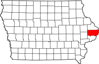
Geotag (location) for:
Clinton co41º53'60"N;90º31'60"W

Clinton (IA) county

Översikt

Historik

Clinton County är ett administrativt område i delstaten Iowa, USA, med 49 116 invånare. Den administrativa huvudorten (county seat) är Clinton.

1835-
In 1835, Elijah Buell built a log cabin for himself and his family and was thus the first settler of the region.
1837-12-21
was Clinton County formed.
1854-
In 1854, the first newspaper was issued and in 1858, the Lyons Female College for girls opened its doors. The tuition was set at $175 per student.

The county has used three courthouses in its history. The structure currently in use was constructed in Romanesque style and opened in 1897.

Övrigt

The county was named for DeWitt Clinton, a Governor of New York and most ardent advocate for the construction of the Erie Canal. The cities of DeWitt and Clinton were also named after him.

består av

  • City
    • Andover,
    • Calamus,
    • Camanche,
    • Charlotte,
    • DeWitt,
    • Delmar,
    • Goose Lake,
    • Grand Mound,
    • Lost Nation,
    • Low Moor,
    • Maquoketa‡,
    • Toronto,
    • Welton,
    • Wheatland.
  • Township
    • Bloomfield
    • Brookfield
    • Camanche
    • Center
    • De Witt
    • Deep Creek
    • Eden
    • Elk River
    • Grant
    • Hampshire
    • Liberty
    • Olive
    • Orange
    • Sharon
    • Spring Rock
    • Washington
    • Waterford
    • Welton
  • Community
    • Almont
    • Bryant
    • Elvira
    • Elwood
    • Folletts
    • Malone
    • Petersville
    • Teeds Grove
plats/us/clinton.ia.county.txt · Senast uppdaterad: 2024/04/03 01:27 av 127.0.0.1