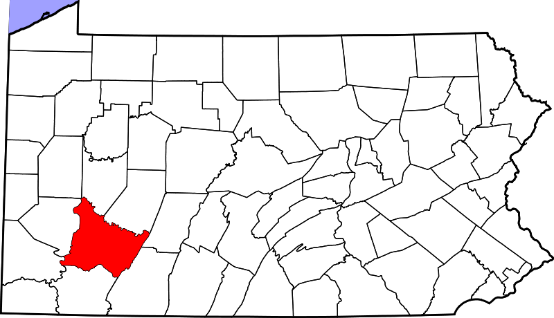
wiki.Ömans.se

Sockenkatalog för släktforskare

Användarverktyg

Webbverktyg


plats:us:westmoreland.pa.co

Westmoreland (PA) county

Westmoreland County är ett administrativt område i delstaten Pennsylvania i USA, med 365 169 invånare. Countyt hör till Pittsburghs storstadsområde. Den administrativa huvudorten (county seat) är Greensburg.

Översikt

Historik

flagga Formed from, successively, Lancaster, Northumberland, and later Bedford Counties, Westmoreland County was founded on February 26, 1773, and was the first county in the Pennsylvania colony whose entire territorial boundary was located west of the Allegheny Mountains. Westmoreland County originally included the present-day counties of Fayette, Washington, Greene, and parts of Beaver, Allegheny, Indiana, and Armstrong counties.

Övrigt

It is named after Westmorland, a historic county of England.

Plats

består av

  • City
    • Arnold
    • Greensburg (county seat)
    • Jeannette
    • Latrobe
    • Lower Burrell
    • Monessen
    • New Kensington
  • Borough
    • Adamsburg
    • Arona
    • Avonmore
    • Bolivar
    • Delmont
    • Derry
    • Donegal
    • East Vandergrift
    • Export
    • Hunker
    • Hyde Park
    • Irwin
    • Laurel Mountain
    • Ligonier
    • Madison
    • Manor
    • Mount Pleasant
    • Murrysville
    • New Alexandria
    • New Florence
    • New Stanton
    • North Belle Vernon
    • North Irwin
    • Oklahoma
    • Penn
    • Scottdale
    • Seward
    • Smithton
    • South Greensburg
    • Southwest Greensburg
    • Sutersville
    • Trafford (partly in Allegheny County)
    • Vandergrift
    • West Leechburg
    • West Newton
    • Youngstown
    • Youngwood
  • Township
    • Allegheny
    • Bell
    • Cook
    • Derry
    • Donegal
    • Fairfield
    • Hempfield
    • Huntingdon E
    • Huntingdon S
    • Ligonier
    • Loyalhanna
    • Mount Pleasant
    • Penn
    • Rostraver
    • Salem
    • Sewickley
    • St. Clair
    • Unity
    • Upper Burrell
    • Washington
  • CDP 1)
    • Bradenville
    • Calumet
    • Collinsburg
    • Crabtree
    • Fellsburg
    • Grapeville
    • Harrison City
    • Herminie
    • Hostetter
    • Lawson Heights
    • Level Green
    • Loyalhanna
    • Lynnwood Pricedale
    • Mammoth
    • Millwood
    • Norvelt
    • St. Vincent College
    • Slickville
    • Webster
    • Wyano
    • Yukon
  • Unincorporated
    • Acme
    • Alverton
    • Ardara
    • Armbrust
    • Baggaley
    • Bessemer
    • Blackstone
    • Boquet
    • Bovard
    • Brenizer
    • Carbon
    • Claridge
    • Forbes Road
    • Greenwald
    • Hannastown
    • Hopewell
    • Hutchinson
    • Jacobs Creek
    • Jones Mills
    • Kecksburg
    • Larimer
    • Laughlintown
    • Lloydsville
    • Lowber
    • Luxor
    • Marguerite
    • Morewood
    • Moween
    • New Derry
    • Pandora
    • Peanut
    • Pleasant Unity
    • Reagantown
    • Rector
    • Reduction
    • Ruffs Dale
    • Salina
    • Scab Hill
    • Seger
    • Southwest
    • Stahlstown
    • Standard Shaft
    • Tarrs
    • Torrance
    • Trauger
    • Turkeytown
    • United
    • Wendel
    • Westmoreland City
    • Whitney
  • Former community
    • Franklin Township - now known as Murrysville, Pennsylvania

1) Census-designated places are geographical areas designated by the U.S. Census Bureau for the purposes of compiling demographic data. They are not actual jurisdictions under Pennsylvania law. Other unincorporated communities, such as villages, may be listed here as well.
plats/us/westmoreland.pa.co.txt · Senast uppdaterad: 2024/04/03 01:27 av 127.0.0.1