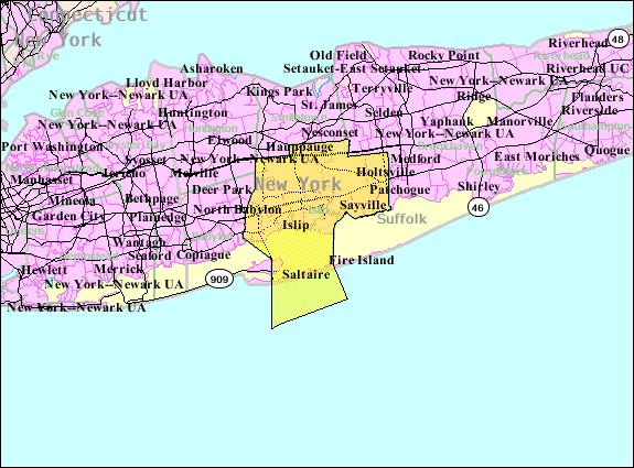
Islip (NY) townIslip is one of ten towns in Suffolk County, New York. Located on the south shore of Long Island, the town population was 335,543 at the 2010 census, it is the fourth most populous City or Town in the state. Översikt
Islip town i Suffolk county i New York state i USA
Arkiv:
Historik
Matthias Nicoll relocated to New York from Islip, Northamptonshire, England, in 1664. His son, William Nicoll, became a royal patentee of the east end of what is now the Town of Islip, and his domain reached from East Islip to Bayport and included Sayville, West Sayville, Oakdale, Great River, Islip Terrace, Central Islip, Hauppauge, Holbrook, Bohemia, Brentwood, Holtsville and a portion of Ronkonkoma. All of this land was bought from Winne-quaheagh, Sachem (chief) of Connetquot in 1683. The yearly fee paid to Governor Thomas Dongan of New York was five bushels of quality winter wheat or 25 shillings. Other early land patentees were Andrew Gibb (Islip Hamlet), John Mowbray (Bay Shore, originally Awixa), Stephan Van Cortlandt (Sagtikos Manor), and Thomas Willets (West Islip). By 1710, the colonial government passed an act to enable the precinct of Islip in the County of Suffolk to elect two assessors, a collector, a constable and a supervisor. The people had a voice. Growth, however, remained at a standstill until the Revolutionary War ended when, in the 17 years that followed, there was more progress than in the 50 years preceding. This activity was partly due to the impact of American shipping. By 1825, it was necessary to install a Fire Island light across the Great South Bay and regular ferry service between Bay Shore and Fire Island began in 1862. In 1867[?] the Long Island Rail Road came to Islip and the first depot was built. People were discovering Islip and the tourist trade soon took hold. Övrigt |
Platsbestår av
|